Monday, December 12, 2016

Hiking Around Reno/Tahoe #10 Sagehen Creek Trail


At the beginning of Summer, as I may have mentioned before, I purchased a book describing most of the hiking trails throughout the Reno/Tahoe area.  I've been using it as a guide since my first hike of the season, "the dreaded Church's Pond episode"!   I learned very quickly what the term "This hike is classified as strenuous" means.  It's a combination of altitude, narrowness of trail,  how many feet the actual climb is (such as you gain 2000 ft).  I also have my gauges.  I look for forested or shady trails.  I like to go the distance rather than start climbing right out of the chute.  I prefer to be near a water source; I'm not into desert hiking AT ALL!

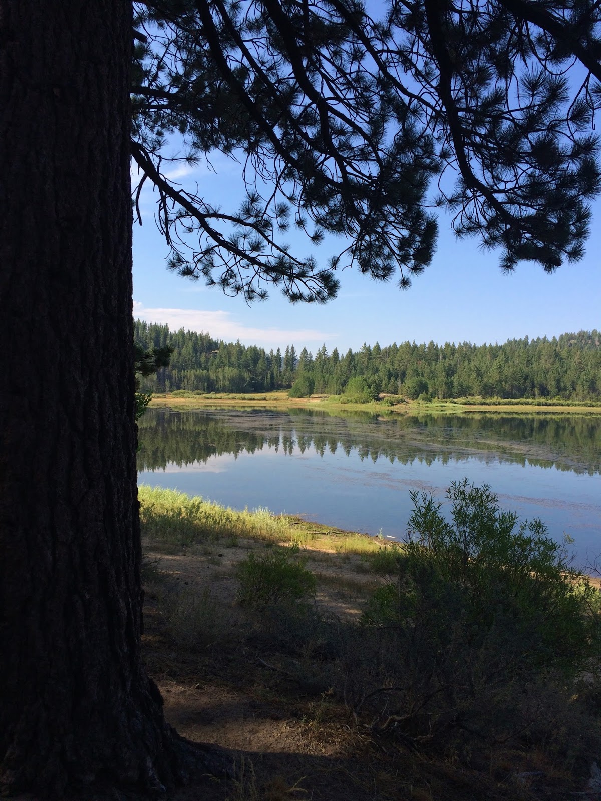
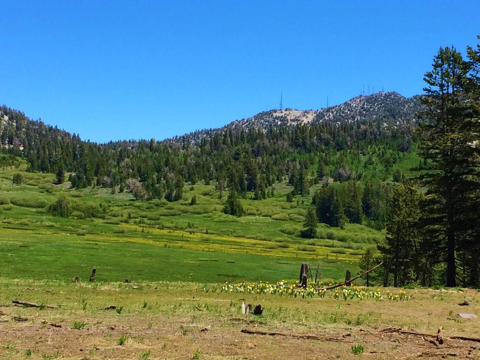
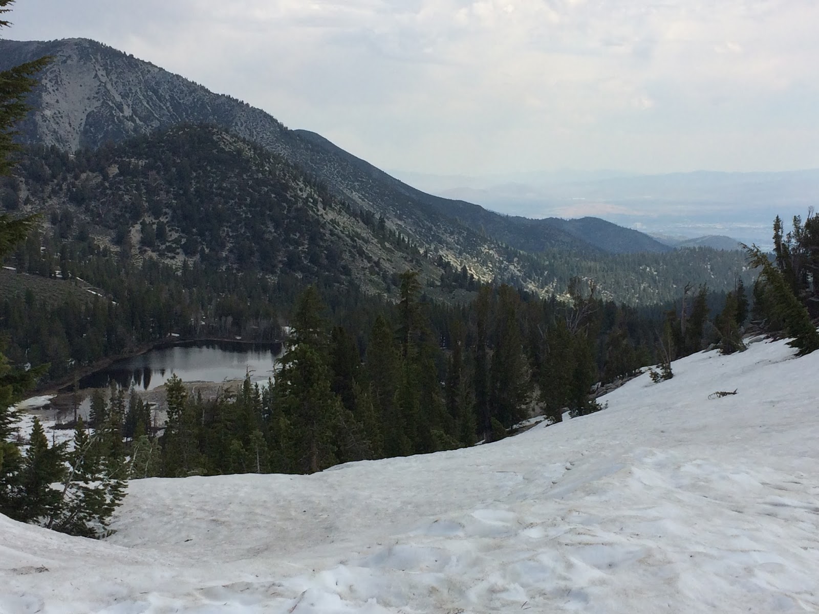
So, with that in mind, the Sagehen Creek trail was almost perfect except it didn't have much uphill climbing.  It was a serene walk in the park.  The trail was mostly narrow, single file even, nicely shaded and scenic.  Only one part comes to mind that could have been a negative.  A clearing of dry grass looking a bit like the Serengeti.  But, after you trudged past this sparsely treed area the view opened up to the distant Stampede reservoir.


Looks like swampland

Serengeti

Stampede reservoir in the distance

Beautiful meadows


The trailhead has limited parking off highway 89 (North).   As you leave Truckee, California go about 7 miles or so to reach it.  It may be worth mentioning that I probably wouldn't hike it in Spring or early Summer.  Mosquitoes and an assortment of other bugs could be a real problem.  This trail was an easy jaunt, just under 5 miles.

I would do this again without hesitation, maybe packing a picnic lunch, a blanket and a book!

Monday, November 7, 2016

Hiking Near Reno/Tahoe #9


Spooner Lake Loop

How many times have we passed this lake located within steps to the highway as we drove up to South Lake Tahoe?  All this hiking has opened up a new love and inquisitiveness of the area we live near.  There is some unbelievable beauty out there if you're willing and able to get "off the path" and onto a forest trail.  The Spooner Lake trail is more of a walk than a hike.  Not much elevation other than the altitude so the only challenge this day was the occasional dodging out of the way as the trail runners whizzed by.  Just happened to be a race going on!

The trail is an informative  one with markers scattered throughout depicting the flora, fauna and a brief history of the area.  There's also plenty of shade from pine and old growth aspen trees that have survived over the years.  What was especially poignant were the "memorial marker" benches along the trail as we made our way around the loop.  It was a way to reflect, say a prayer and realize how fragile life is. 

We did this in early August so the lake level was low.  We did part of an adjacent Marlette trail earlier in June, but the mosquitoes were out for blood that day!  I would imagine the Fall would be gorgeous as the aspens display their colors....

Get out and walk if you can!


a great day

walk in the woods

very tough and old aspens

view from a memorial bench

educational

finishing up the loop...done counterclockwise

Monday, September 26, 2016

Zucchini Bread


My husband has this saying and he's usually right.  "Don't change horses in the middle of the road" or "If it's not broken, don't fix it".  I recently tried to fix it using a different recipe for zucchini bread.  I'm sure the recipe probably worked but in my rush to bake this delicious bread, I grabbed the wrong measuring cup, thus using half the amount of flour for the bread.  So, as I watched the oven, needless to say after ample amount of baking time, the bread was still like mush.  All was not lost though.  I grabbed some frozen blueberries and proceeded to build a blueberry cobbler, of sorts.  It turned out okay, but lesson learned on measuring correctly.

I realized while glancing through my blog that I hadn't posted my zucchini  bread recipe which is fairly fool proof!  It's the perfect way to put a dent into a huge zucchini harvest!   Hopefully it works for you....

Zucchini Bread

3 eggs
1 cup oil
2 cups sugar
2 tsp vanilla

In a large bowl, beat until foamy.  Add 

2 cups shredded zucchini
1 c crushed pineapple

In another bowl blend (I use a whisk instead of sifting)

3 cups flour
2 tsp baking soda
1 tsp salt
1/2 tsp baking powder
1 1/2 cinnamon
3/4 tsp nutmeg

Add the flour mixture into the egg/sugar mixture  folding until well blended.  Add the 

1 cup raisins
1 cup chopped nuts (I like pecans)

Pour into 2 greased loaf pans and bake at 350 degrees for about 1 hour and 15 minutes or until a knife inserted into the middle comes out clean.  Enjoy! 


Saturday, September 10, 2016

How I Spent My Summer Vacation #1


Summer vacations from the past have usually been few and far between consisting of a quick weekend here or there.  One year was spent in Half Moon Bay, CA, on the coast hiking, relaxing and enjoying fantastic seafood.  Another, was spent in Santa Fe, New Mexico.  These were relatively quick trips coinciding with my birthday or our anniversary in July.  I have to admit, I felt a tinge of jealousy as we somehow managed to be in Venice, Tuscany and France during hubby's October birthday.  I guess it "just happened" that way!

This Summer I jumped at the chance to go on a RV trip to Yellowstone and Jackson, Wyoming.  It was everything I envisioned and more.  It truly is "God's Country" with miles of pristine forests, rolling hills and meadows filled with wildflowers, bubbling cauldrons dotting the landscape and incredibly blue sky.  We were lucky to see elk, and buffalo/bison but fortunately no bears or mountain lion even though on one of our hikes, the Ranger suggested we take our bear spray from the holster and "be ready"!

Although the Yellowstone area swells in population during July you can still have moments of solitude if you get off the beaten path and away from the famous "Old Faithful".  We were able to experience this solitude when we drove up into Montana just north of West Yellowstone.  Sometimes if you're willing to "get lost" those beautiful and memorable adventures will follow.  On the northern end of Lake Hebgen a river runs through it.  One of my all time favorite movies was being played out as we approached the river's edge on our hike through knee high wildflowers.  Fly fisherman lined the shallow banks and if we would have had more time I would have loved to watch more of their graceful casting.

Continuing on this hike we somehow lost the trail.  Maybe the scenery was too gorgeous because between the four of us we found ourselves blazing a new trail through an evil (think Wizard of Oz, flying monkey forest) prickly overgrown forest.  With each step the stickers dug into my ankles and barbed their way into my skin.  Unfortunately, our friend's dog suffered the brunt of the stickers as they quickly burrowed into her fur and skin.  Poor Lulu!  It took a while but Lulu got a "new hairdo" that day as we took turns snipping, pulling and cutting away the thorns.

All the trauma aside this was one of the most gorgeous mountain areas I've been to in a long time.  Pictures NEVER do it justice.  You'll just have to take my word for it.  BREATHTAKINGLY BEAUTIFUL 


gorgeous wildflowers

Lulu on the trail

hubby admiring the view

Beautiful scenery = lost trail

Lake Hebgen, Montana
More to come!

Monday, August 29, 2016

Hiking Around Reno/Tahoe #8 Near Marlette Lake


Variety is the spice of life.  Just as this saying holds true, variety in hiking, for me, is the key to continue onward and upward.  I can't tell you how many times we have driven past this trailhead over the course of 40+ years.   There's so much interesting history in the hills and woods of Reno/Tahoe so I'm almost embarrassed to say it took so long to begin hiking these trails!

This special hike was in preparation for our RV trip to Yellowstone and the Tetons near Jackson Hole, Wyoming.  We knew we'd encounter high altitudes, mosquitoes and probably bear!  So, we armed ourselves with our bear spray and repellent for bugs.  Okay, so we didn't see any bear on this trail to Marlette Lake, but the bug spray sure came in handy.  In fact, the mosquitoes were so bad we didn't complete the trail to the Lake.  The mosquitoes even bit through clothing!

All in all  the trail was a steady climb once you made the turn off away from the creek.   There's a lot of dappled shade along the trail which made it pleasurable instead of strenuous even though we climbed in elevation and were drenched in sweat from the steamy morning.  I'd love to revisit this trail in the Fall when the trees turn colors, the mosquitoes die off and when the temperatures are in the mild 60's or 70's.  I'm not asking for much, huh?

Now for some pictures!  The one above is called Spencer's Cabin (keeper of the cattle on the ranch).


 The easy part of the trail before elevation and switchbacks.


The branding symbol for the cattle ranch.


 Beautiful hidden meadows filled with mosquitoes!


Spooner Lake


Thursday, August 4, 2016

#7 Hiking Around Reno/Tahoe


July 3rd

Because it was the July 4th Holidays,  the planned trip to the Mount Rose summit trail was once again postponed!  By the time we arrived at the summit parking lot (before 8am) it was jam packed. We opted to take the easy trail less traveled...The Tahoe Meadows Interpretive Loop Trail, a meandering 1.2 mile loop.  To increase the mileage we continued on the North end to the campsites and also veered off the trail in some spots (but you didn't hear that from me) where you could get a bit of heart pumping climbs.

The trail is filled with wild flowers.  It's beginning to sound like a broken record, but this year the flowers in the forest and meadows are especially abundant!  I would almost classify this as a WALK instead of a hike....a beautiful walk in the woods and so close to home.  This Tahoe trail is educational and one of the best starting points for a high altitude jaunt at over 8800ft.

We've hiked this trail many times however, with the change of the seasons and the ever changing snow pack amount totals from year to year, the scenery never disappoints.


Stay tunes for the next hike to Marlette Lake area and in a later post
our hiking adventures in Yellowstone and Jackson Hole, Wyoming!

Monday, July 25, 2016

#6 Hiking Around Reno/Tahoe


June 25th

Today's hike has to be labeled "most scenic".  It's the "Tunnel Creek loop" of the Tahoe Rim Trail on the Eastern ridge of Lake Tahoe.  The actual length is about 23 miles ending up at Spooner Summit, but we chose to only do a portion (6 miles total).  You start in the Tahoe Meadows off Hwy 431 for a walk in the woods.  Veer to the right and begin an ascent which is not really strenuous but will get your blood pumping until you reach the highest point on the ridge (around 8800 ft).  You are immediately rewarded with one of the prettiest views and for the hike along this ridge the views are king!

It might be worth mentioning that this trail is frequented by mountain bikes also, however they are limited to odd number days only.   Even though hikers have the right of way we normally pull to the side to let them pass especially if they are headed uphill!  It has to be hard to gain your momentum on a bike.

The trail skims the top of the mountaintop and winds around through the forest so there's always a chance of welcome shaded areas.   You even pass over a few creeks along the way!  The trail is littered with car size granite boulders, occasional wild flowers and spectacular views at every turn.  

I will do this again in it entirety perhaps in two days, splitting it up near the Tunnel Creek cafe.

It's hard to tell from the picture but these sure look like mountain lion prints!


 Views of the lake

Beautiful meadow


Tuesday, July 5, 2016

#5 Hiking Around Reno/Tahoe


DRY POND VIA THOMAS CREEK TRAIL

What a difference hiking shoes make?  No more smashing toes as I head down the trail!  I "tested" them out on the way to Dry Pond via the Thomas Creek trail recently.   We set out on a crisp cool morning on a trail off Timberline Road.  The trail runs parallel to the Whites Creek trail which also ends up at Dry Pond completing a loop.

If ever there was a "perfect hike", this would be it.  The weather was mild, the trail was a nice blend of strenuous climbing in spots, but mostly shaded, an easy meandering trail with many switchbacks.  It begins hugging the creek with plenty of places for an impromptu picnic.  In some spots it looks like something from the Shire with dried cave-like looking reeds.  Along the length of creek is an occasional mini waterfall, wildflowers including edible wild garlic.  It's easy to see why there could be deer, bear and mountain lions in this habitat.  Wildlife smorgasbord.  I just don't want to be their main entree!

At mile marker approximately 1.5 miles the trails says goodbye to the water and rises back and forth until you reach the summit or Dry Pond area.  Grab a seat on a downed log, relax, have lunch and take in the beauty.  There's plenty of it!  You can continue the loop back or just turn around and retrace your steps, which is what we did.

We will definitely walk this trail again.   I can't wait to return in the Fall, should be ablaze with color this year!


Lion, cougars and bears, oh my!

Cool pools

View of Truckee meadows from one of many switchbacks.

The summit - Dry Pond

Photo op


I know he wants to put his feet in the water!


Sunday, June 26, 2016

#4 Hiking Around Reno/Tahoe


AN ATTEMPT AT MT ROSE SUMMIT One of the highest mountain peaks in the area for hiking is Mt. Rose.  With an elevation of 10,776 it's definitely on the bucket list and the "big daddy" of accomplishment in this area.  The hike is roughly 9.6 miles total up and back.  About halfway there, Galena Falls tumbles down granite slopes, or so I've been told.  We made the attempt a few weeks ago, but after a mile or so, we were trudging (slipping and sliding) in snow.  Back down the trail we went only to pursue it another day!

Even the Tahoe Meadows were snowy and too muddy!  What's a hikeaholic to do?  Find another trail to walk/climb.  I'm not sure if we found an actual trail.  it looked like a service road used by the power company, but it would do, maybe?  We climbed this for awhile and stopped for a picnic lunch, once again in the snow.  As we began our return to our car we noticed some suspicious foot prints crossing the "trail".  I remember researching an article about what type of animals we could encounter accompanied by pictures of  their footprints.  Not from a bear; that's good.  But, not a rabbit or domestic dog either!  Hmm....looks like mountain lion!  

After that I spent most of my hike in hyper vigilance wishing I had eyes in the back of my head.  It was a bit unsettling!  We put in the miles (not really enough that day) but, the views around Lake Tahoe are so majestic....I never get enough!


View within a mile of trailhead

Snow covered trail already!

Elevation over 9000ft

Lake Tamarack over the ridge

Not much into selfies, but I needed proof I was there!

Assuming this was a trail.  There is a lone bicycle track.

Always looking for the view!

Friday, June 17, 2016

#3 Hiking Around Reno/Tahoe


Yet another hike!  Hey, it beats sitting on the couch!  We chose Brown's creek "lollypop" loop which is right up the street.  A lollypop loop is a straight trail which loops at the end to make a lollypop.  Think tootsie roll pop!  What we thought was a 4.8 or so hike, turned out to be more like 6.1.  

Let's begin.  There is a parking lot across from the beginning of the trailhead which is off of Joy Lake Rd.  It began with a steady ascent through a canopy of shaded forest.  With all the rain we received this year wildflowers were in bloom and made the going beautiful.  As we made our way to the summit there was a "side trip" trail called Sundown Town.  Evidently, a group of investors had plans to make a theme park of sorts during the early 60's.  That's the first I had ever heard of this.   

Heading back to the main trail we veered off to the right and down into the canyon area where the Brown's Creek flows down from the mountain.  Ah, nice shady aspen groves!  That was the nice part.  After crossing the creek we began to climb again as did the temperature that day.  There seemed to be plenty of obstacles such as rocky trailbeds to maneuver and a lot of loose rocks to make your feet slide.   And slide I did, swearing with each step and vowing to buy some new hiking shoes that would grip better.

Brown's creek trail, to me, was becoming a nightmare of sorts and I began to question whether my feet and/or my knees would make it in one piece!  At the bottom of the trail which was a little over half way we crossed the creek once more and began our ascent back to the main trail.  With  the sun beating down on us by this time, the climb seemed to be a struggle, for me.  For hubby, not so much, so trying to stay at his pace was getting to me (and my attitude went sideways!).  I just wanted to get off this trail as soon as possible! 

Well, I'm here to tell you I survived this one.  Cross it off my list.  Done!   Later that evening at our friend's house for dinner our hike was mentioned.  My friend looked at me with scary eyes as she exclaimed to me that that was where the mountain lion hangs out!  Hmmm!  

  Would I do this hike again?  Maybe, just the first part, not the whole loop!  Stay tuned for more fun!  


 Did you know?

 Beautiful vistas

 More nice views

Wild morning glories?


Cool aspen grove - possible mountain lion/cougar country?